New Islet Broch (possible) Discovered at Holms of Hogaland, Whiteness, Shetland

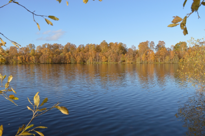
A new monumental drystone roundhouse was discovered while conducting underwater and terrestrial archaeological survey in Strom Loch, Whiteness, Shetland. The site is the central of three islets, called the Holms of Hogaland. This site has not been identified to date, and will be a new entry into a long list of brochs and possible brochs known in Shetland.

eroding_side
First views of the possible broch.

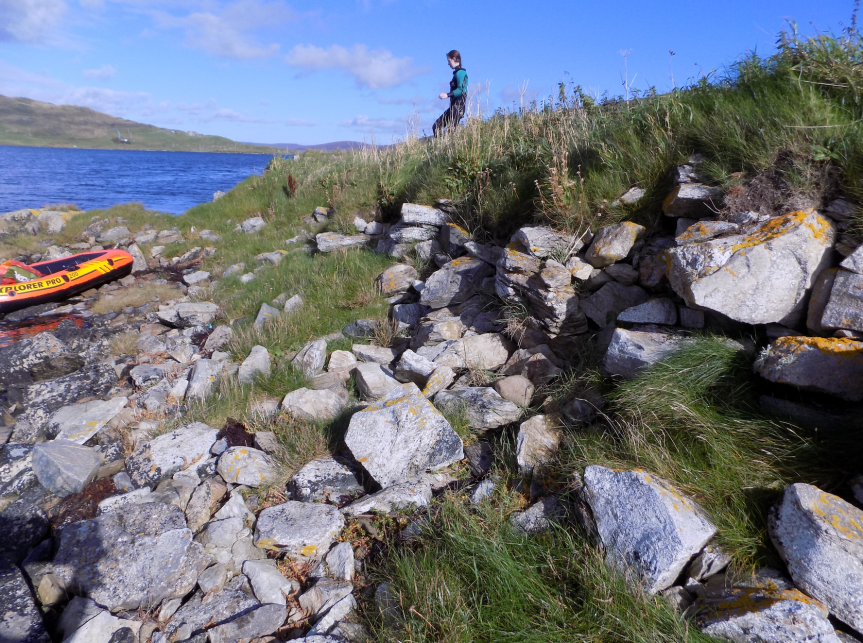
In conducting survey at Castle Holm, Strom Loch, Shetland the opportunity was taken to investigate a small islet across the loch at the Holms of Hogaland. I was tipped off by Claire Christie, who is working at the Shetland Amenity Trust using high resolution aerial photographs to map Shetland’s Sites and Monuments Record, that there may be a causeway out to the island. Upon inspection, myself and Sally Evans (an intrepid volunteer) were amazed by what we saw.

internal_depression
The internal depression.

The majority of this islet was covered in a large mound around three metres high and about 16x14m across. There were obvious structural features, including coursed stonework and potentially the remains of orthostats or piers (ie. internal divisions within the former structure). In the middle of the island is small circular depression about four metres across that presumably represents internal space within this large structure. On the west side of the island, and most exposed to the weather, there appears to be some active erosion, although the rate and extent of this is difficult to know as there is no baseline of information with which to compare.

orthostats
Possible orthostats or piers.
internal_walls
Exposed walling in the interior depression.

Bedrock can be seen at the edges of island, so it is clear that this islet is not completely artificial, however, it seems likely that a significant portion of the current islet underwater is composed of material transported to the site. While not a crannog in the classic sense, it may well prove that sites like this newly discovered site are assuming similar roles as crannogs in Iron Age Scotland.

The monumental architectural forms of Iron Age Scotland (crannogs, brochs, wheelhouses and duns) are frequently conceived and discussed as self-evident categories of settlement types. However, any close inspection of how these archaeological terms are defined reveals that these units are not so clear cut – a topic that has been the subject of large tomes of published literature. It seems clear, though, that we are instead looking at a spectrum of round (mostly domestic) architecture where the lines between broch and dun, crannog and an occupied natural islet remain blurred. When considering crannogs and islet settlement, Shetland presents a wide array of different types ranging from completely artificial occupied islands to natural islands with monumental roundhouses placed on top. For this reason, it represents a foil to studies of mainland crannogs (such as the main focus of my PhD research), and hopefully will help break down our archaeological terminology and definitions and peer into an understanding of what monumental domestic architecture meant to the people of Iron Age Scotland.

Stay tuned for further updates on islet brochs and duns in Shetland!

Thank you to Sally Evans, it would not have been possible to do this work without her help!  Thank you to Esther Renwick and family for use of the small dinghy, it worked brilliantly. Thanks also to Claire Christie for the tip-off on the presence of the causeway. And finally thank you to Val Turner for her support.

A flight over Loch Kinord

I recently was very lucky to be a guest of the Deeside Gliding Club and had the opportunity to experience Loch Kinord from the air. Below are some highlights and a short video.

This slideshow requires JavaScript.

The perspective available here is really incredible. You can get a map view from above but you also get to be in the landscape rather than looking at it on paper or on a computer monitor.

VIDEO HERE

More updates on the Loch Kinord crannogs and other crannogs around north-east Scotland will be posted here in due course.

Thank you to John Dransfield who was pilot for the flight.

Likely Iron Age Origin for Castle Island: Radiocarbon results from Loch Kinord

An Iron Age phase of construction at Castle Island, Loch Kinord has been identified through radiocarbon dating. The date comes from a submerged timber on the west side of the island, which lies horizontally protruding from the underwater portion of the island. This is the first evidence for Iron Age activity from the occupied islands in Loch Kinord as they previously had radiocarbon dates from the 9th century AD onwards. The other significant evidence this radiocarbon date provides is that it may suggest that Castle Island is more artificial than the excavation in October seemed to suggest, and therefore takes us back to our original interpretation that Castle Island is wholly or mostly artificial as opposed to natural with significant modification.

Timber_01_Screenshot_outline
Submerged horizontal timber from Castle Island, Loch Kinord. This timber was sampled and radiocarbon dated to the Early Iron Age. Approximately 1.6m of the timber is exposed.

This is the first Iron Age crannog confirmed in north-east Scotland. The result puts Castle Island (and perhaps all of the crannogs of north-east Scotland) much more in phase with other radiocarbon dated crannogs throughout Scotland. The majority of radiocarbon dated crannogs have initial phases of construction and occupation in the Iron Age with periodic re-use through the early medieval and medieval periods (There is a book chapter available HERE by Anne Crone on this subject; the chapter begins on pg. 139). The Iron Age phase at Loch Kinord is very exciting as it opens up the crannog history of Loch Kinord (and arguably the region) by over 1500 years. Furthermore, the outstanding preservation of the landscape around Loch Kinord means that good contextualisation of the crannog occupation is possible within a range of settlement archaeology that includes houses, souterrains and field systems. These likely Iron Age structures may date to the same period of construction indicated by the Castle Island radiocarbon date. The group of roundhouses at Old Kinord was recently investigated by Tanja Romankiewicz and Richard Bradley which will be the first modern investigation of this remarkable survival of domestic architecture, and will undoubtedly add to our overall understanding of the Loch Kinord landscape.

Castle_Island_all_dates
Radiocarbon dates from Castle Island.

As it stands, Castle Island is unique for having an Early Iron Age phase as well as 10th-12th century AD phases indicated by radiocarbon dating. The two radiocarbon dates from the terrestrially excavated contexts on Castle Island are virtually of the same 11th or 12th century AD determination. At this time, it seems that Castle Island is enlarged with a large quantity of earth brought to site, and in many ways this phase of use at the site might be characterised as the development of an insular island motte. This almost certainly relates to this site being put into use as a castle residence for incoming elites as Scotland coalesced into a feudal medieval kingdom in part through the import of loyal nobility. There is also the possibility that the people responsible for commissioning and building this and other elaborate island residences were native elites emulating styles associated with new hierarchies of power but within a familiar vernacular of important residences that had been around since the Early Iron Age. There are a growing number of crannogs in eastern Scotland which are demonstrating use from the 10th-12th centuries AD. Notably, at Lochore Castle in Fife, excavations directed by Dr Oliver O’Grady have revealed 10th-11th century AD occupation with later elaboration in the form of a surviving stone tower house. You can read more about the Lochore Castle project HERE. The question that remains is whether all or only some of these medieval crannogs have phases of earlier use.

Prison_Island_all_dates
Radiocarbon dates from Prison Island.

In addition to the radiocarbon date from Castle Island, a third radiocarbon date from Prison Island has been recovered, and for the first time at Prison Island, this sample comes from an excavated context. The date is further strong evidence that Prison Island was in use at the same time as Castle Island. The material radiocarbon dated probably relates to some hearth waste. The previous two radiocarbon dates, which bracket this one, came from structural material (an upright pile and a horizontal timber). Why Prison Island and Castle Island were in use at the same time is probably, although not necessarily, more nuanced than their names imply. Importantly, Prison Island is referred to in the Old Statistical Account and labelled on the First Edition of the Six Inch Ordnance Survey as ‘Tolbooth’. Tolbooths performed a range of functions in medieval Scotland, including being used as prisons, but also as town council chambers and court rooms. Whatever their purpose, it is now very likely that Castle and Prison Islands were in contemporary use. The implication is a more complex dynamic of island occupation than previously considered, perhaps with further controls on access and division of functions during medieval re-use of crannogs.

Funding for this work has been provided by the Society of Antiquaries of Scotland, the Aberdeen Humanities Fund and Aberdeenshire Council. I must thank everyone who has helped carry out this work, Dimitris Papakonstantis, Tim Stephen, Ailidh Brown, Julia Scheel, Seòna Wells, Duncan MacGregor, Ross Cairnduff, Euan MacKenzie, Claire Christie, Carly Ameen, John Witold, Juliette Mitchell, Tessa Poller and my supervisor Gordon Noble. Permission for this work has been kindly granted by Catriona Reid, Muir of Dinnet National Nature Reserve Manager.

Underwater Investigation at Loch Kinord – 16-18 October

Work at Loch Kinord continued again this past weekend. Surprisingly, visibility conditions in the loch surpassed all expectations allowing more to be achieved in this single weekend than all of the previous underwater work conducted to date. With help from volunteers from the Aberdeen University Sub-Aqua Club and Deeside Sub-Aqua Club, we examined the submerged portion of Castle Island.

Castle Island is first recorded as being in use in AD 1335, when the remnants of the Earl of Atholl’s defeated troops took refuge there following the Battle of Culblean Hill (they surrendered the next day). The castle was in use throughout the next 300 years, but was razed by Act of Parliament in 1649. My previous work at Castle Island indicated that remains of the causeway structure referred to in Reverend J. Michie’s 19th century antiquarian account of Loch Kinord survive, and one of the timbers likely to be part of that structure returned a radiocarbon date from the 10th century AD. The work we undertook this past weekend aimed to shed more light on what remains on the loch bottom, and take C14 samples that might add further detail to the chronology of use at Castle Island.

Timber C14 dated to the 10th century AD.
Submerged Timber on north side of Castle Island.

What we discovered did not disappoint. It is now clear that there are a group of vertical piles on the west side of Castle Island. These piles stand about 5-10 metres from where the artificial mound meets the natural loch bed. For what structural purpose these piles relate to is unclear, but an outer palisade or some kind of pier or jetty seem possible. I suspect that many more vertical piles survive just under the sediment of the loch bed, having eroded away through time. The piles that do survive above the loch bed have done so because they are likely to be oak heartwood, the sapwood having disappeared already (if it wasn’t removed during the fabrication of the pile).

In addition to the piling, the west side of the island has also at least two examples surviving of horizontal timbers emerging from the artificial mound. This is also the side of the island where we identified a possible logboat in 2011. That feature was found again, but its status as a logboat is very much in doubt having now been able to look at it completely in good visibility. Close examination of the images captured of this tree/logboat will hopefully settle the issue.

Despite the good visibility, as always, when the bottom sediment was stirred up, the visibility quickly reduced.

Poor visibility always occurs when even the lightest touch or fin stroke is applied to the loch bed.
Poor visibility always occurs when even the lightest touch or fin stroke impacts the loch bed.

There is a lot more work to be done at Castle Island, including upcoming excavation on the island itself.

I would very much like to thank the divers and helpers who made this work possible. Thank you to Dimitris Papakonstantis, Tim Stephen, Ailidh Brown, Julia Scheel, Seòna Wells, Duncan MacGregor, Ross Cairnduff, Euan MacKenzie, Claire Christie, and Carly Ameen. Thanks also to Catriona Reid for help and permissions to do this work at the Muir of Dinnet National Nature Reserve. Finally, thank you to the Society of Antiquaries of Scotland for providing funding for this archaeological investigation.

The Royal Yacht

I have written a number times in this blog of details concerning the logboat find from Loch Kinord known in the 19th century as the Royal Yacht, however, the recent AD 550-650 radiocarbon result has prompted me to bring all that detail together in a single post here, as well as add some of my additional thoughts.

The Royal Yacht was found in 1858 in Loch Kinord, during a dry summer. This was the first logboat discovery from Loch Kinord (a further three at least were discovered, including two in close proximity to each other near the west shore of the loch and a third near Prison Island). The name ‘Royal Yacht’ was given to the find in reference to the loch’s local association with Malcolm Canmore. Although, only six years previously, Queen Victoria and Prince Albert bought the nearby Balmoral Castle, and ‘Royal’ associations were very much in vogue at the time.

In 1859, the boat was removed from the loch by a team of over 50 people using poles and ropes. The antiquarian Rev. J. G. Michie describes some detail concerning the boat, most notably two large splits which appear to have been repaired in antiquity using ‘dove tailing’ joints to prevent further splitting. The boat was displayed in Aberdeen the following year and then taken to Aboyne Castle. It seems that during its time in Aboyne Castle the boat largely disintegrated (a common fate among logboats discovered in the 19th century – only around 20% of logboats found in the 19th century survive to this day), but a fragment survived and was donated to what has become the Marischal College Museum Collection. This was what was radiocarbon dated.

The group of logboats from Loch Kinord are a rather remarkable collection from a single loch. In addition to the logboats, accounts of ‘innumerable’ wooden artefacts recovered from Loch Kinord in the 19th century speak to the incredible preservation conditions in Loch Kinord. I have cut together a brief video of underwater footage from within the loch that can be viewed at the link below. The first part of the video shows just how good the visibility can be in the right conditions, and the second part just how poor they can be too.

Video Link [[HERE]]

What is also amazing to think about it, is that the preservation in Loch Kinord is unlikely to be especially unique. Loch Kinord’s water benefits from less intensive agriculture around its shore and in its catchment area, but regardless, there are many hundreds (if not thousands) of lochs in Scotland with similar preservation conditions.

Since there is no telling the date of the other logboats from Loch Kinord, we must look further afield for parallels to the Royal Yacht. I briefly discussed in a previous post the logboat from Loch of Kinnordy, and this boat’s carved animal bow is an intriguing detail potentially hinting at what might have been lost from the Royal Yacht. There is a further animal carved bow logboat dating from the 5th century AD – the Errol 2 logboat. This boat was found by fishermen in the inner Tay estuary in 1895. You can read the Canmore site record [[here]]. While there is no evidence of an animal carving on the bow of the Royal Yacht, Michie describes the logboat being found in very shallow water and the upper portions of the boat being ‘worn down’. It is tempting to think that the Royal Yacht also featured an animal carving on the bow too.

Radiocarbon dated logboats from the Early Medieval period in eastern Scotland

Using animal imagery on watercraft has an exceptionally long history throughout the world, and indeed there are numerous arguments amongst maritime archaeologists that animal shapes were used to inform crucial elements of boat and ship design as recently as the 18th century. Whether animal form was used in logboat design is difficult to prove, although the longevity of the logboat building tradition might to speak to its conceptual and design simplicity. However, the relationship between animal imagery and watercraft goes far beyond design and concept.

It is easy to imagine, although the archaeological evidence remains scant, that animistic belief systems were prevalent in the first millennium AD in Scotland. The best evidence we have from this period comes from symbol stones where animals are depicted with some frequency (although by no means the most numerous group of symbols). Salmon, birds and the Pictish beastie all appear on a number of symbol stones. While not the only interpretation, Pictish symbol stones may have communicated some kind of identity, and it is possible that animal carvings on logboats were communicating a similar thing as a kind of ownership. This may not have been straight forward property ownership as we might think today (i.e. I carved my name on it so it is mine), but perhaps it was communicating that by boarding the logboat you were now in someone’s sphere of control. This idea ties in nicely with what is recorded in Early Medieval literature in Ireland regarding crannogs which describe in a number of places crannogs as having designated harbours or landing sites on shore and that these harbours were viewed as part of the area under the control of the crannog.

I do not wish to undervalue the practical element of logboats, they certainly would have been useful to get from point A to point B. However, like crannogs, the less functional aspects of logboats are intriguing, despite the details remaining archaeologically elusive. Further investigation at Loch Kinord may be able to shed light on the landscape (or waterscape) that the Royal Yacht and the other logboats known from Loch Kinord were used. Investigating how these boats might relate to Castle and Prison Island as well the as wider archaeological landscape around the loch is likely to yield interesting results.

Snorkelling Loch Kinord 26th and 28th February

I have had a chance to get a couple of days of snorkelling in at Loch Kinord. There is more diving fieldwork to come over the next week, but I thought I would share a few photos that have come up. Conditions have been quite tough, water temperatures less then 2°C and high winds have limited what we’ve been able to do.

Blurry photo of possible timber at Castle Island, Loch Kinord
Submerged section of Prison Island crannog, Loch Kinord

Lots more work to be done with the data collected, hopefully with discoveries coming up from some careful examination of the photos. Thanks to Seòna, Tim, Robert and Claire for helping out.

Seasonality and Crannogs

The weather of the past few days here in Aberdeen has hinted that Spring is not too distant. It is so often archaeologically invisible, but even in modern times, where we benefit from climate controlled everything, changing seasons guide, shape and organise our lives. The ordering of life that seasonality places on a mostly or wholly agrarian society would be difficult to overstate. Throw in the foibles of changing weather year to year, month to month and day to day and it is easy to see how whole cosmologies developed around seasonal cycles. But within the discipline of archaeology seasons are not regularly discussed, and where they are, seasons tend to be discussed within works dedicated to addressing archaeology and seasonality specifically. This must stem from the fact that detecting archaeological evidence for seasonality is not always present or immediately obvious, and if possible at all, normally requires specific scientific analyses.

Castle Island, Loch Kinord from the north shore.

With respect to crannogs we can imagine that different seasons would have played a large part in daily life on a crannog, and may have been (as some have argued) the very reason they were constructed and occupied in the first place. It is difficult to imagine living on a crannog in highland Scotland through the winter. Out on the water is an exposed place, and doubly so in a crannog if you accept the idea that they were originally free-standing pile dwellings (ie. without the benefit of having ground, artificial or otherwise, beneath your habitation). This has led some to suggest that crannogs were only occupied in warmer months, but there is not yet widespread evidence for seasonal occupation. However, it is an attractive hypothesis that crannogs were occupied seasonally given just how cold it must be to occupy such a location through Scottish winters in the past (or indeed in the present).

Prison Island, Loch Kinord from the east shore.

Another idea has been proposed that suggests climactic downturns may have played a role in the construction and occupation of crannogs. Anne Crone compiled every radiocarbon date available from crannog sites in Scotland (this book chapter is freely available [[here]]), and she noted that there appears to be clustering of the radiocarbon dates at times which coincide with periods of deteriorating climate. This idea makes less intuitive sense as a wetter and colder climate would possibly make crannogs a less appealing habitation. But if we put aside personal comfort, it was perhaps the stresses that a deteriorating climate put on groups of people that necessitated building a crannog. If this is the case and crannogs were built in response to periods of colder and wetter climate, the reasons why building a crannog was necessary remain an intriguing question. Whether or not crannogs were occupied seasonally is perhaps less important than realising that all of Iron Age and Early Medieval society (crannog dwellers included) would have had their lives impacted and shaped by changing seasons. In a society where agriculture was the work of the vast majority of people seasons and seasonality are critical elements of everyday life.

17th IARSS Conference (30-5-14)


Last weekend I was in Edinburgh presenting my research at the annual Iron Age Research Student Symposium. The paper I gave concerned loch drainage as identified using the Roy Military Survey of Scotland (1747-1755). My arguments seemed to be well received by the conference attendees. The results of the research I presented now leaves me with a list of possible crannogs in drained areas. Over the summer I will examining these sites to test my hypothesis, are these sites crannogs? Below is the abstract for the presentation.

Crannogs possibly represent the most archaeological potential of any single site type in Scotland. This is due to the preservation conditions of their waterlogged or submerged nature, but also for the vast quantity recorded in the country, with counts ranging from 400-600 and some suggestions of over 1000. Despite this potential, very few have been excavated in the past 60 years owing again to their submerged or waterlogged locations. Additionally, all excavations and most other work has been conducted in two specific regions of Scotland – the southwest and Loch Tay, Perthshire. This paper argues that the reason for this geographical focus is not a reflection of the past distribution of crannog sites, rather this bias stems from the timing and location of loch drainage in the 18th and 19th centuries. Through an analysis of the Roy Military Survey of Scotland, editions of the Ordnance Survey, and the Statistical Accounts of Scotland it is clear that drainage in eastern parts of Scotland was more widespread and occurred at an earlier date than elsewhere in Scotland. The ramifications for our understanding of crannog distribution and survival will be emphasised. One important observation is that the research focus on southwest Scotland is, in large part, due to the fact that drainage occurred here when antiquarians, most notably Robert Munro, were around to monitor its effects. This paper will call for the established distribution of crannogs to be reconsidered in favour of a broader and less regionalised model.

Previous Crannog Research in Northeast Scotland

This will be a short post as there is not much to report here…I consider the northeast for this purpose to be the area made up of the modern council boundaries of Aberdeenshire, Aberdeen City, Angus, Dundee City, Fife and Moray. The sum total of crannog excavations carried out in this region (a combined area of 12,189 km2) is two. The latest of these excavations took place in 1868 in Loch Forfar on St. Margaret’s Inch (John Stuart’s account of this excavation). The other took place in 1850 in the Loch of Leys near Banchory, Aberdeenshire. Both of these excavations were carried out by amateur antiquarians, and the results of which, while informative, are not up to modern standards. A good example of this is J. H. Burnett’s account of the Loch of Leys excavation where he laments that a worker ran off with some coins found on the site that day.

Loch of Leys Crannog, Aberdeenshire. Partially excavated in 1850.
Loch of Leys Crannog, Aberdeenshire. The extent of the site is indicated by the two taller trees in the centre of the photograph. The site was partially excavated in 1850.

The identification by sight of several other crannog and possible crannog sites and very minor pre-development excavation on St. Margaret’s Inch in 1995 (report, pg. 12) plus my initial investigations in Loch Kinord, Aberdeenshire comprise all of the crannog research conducted to date in northeast Scotland. There are a number of reasons why so little research has been done, and a large part of my research has been dedicated to better explaining these reasons. But effectively it boils down to the widely accepted map of crannog distribution in Scotland which has considered the whole eastern half of Scotland to be a backwater of crannog construction. However, there definitely are crannogs (and perhaps many more than previously acknowledged) in this region and they deserve further attention.

In the next few posts I will detail the fieldwork I organised in Loch Kinord, Aberdeenshire and the other research I have conducted. Stay tuned!

What is a crannog?

What is a crannog? The simple definition would be that they are small artificial islets found in Scottish and Irish lochs (loughs) which were built mainly from the beginning of the Iron Age through the Early Medieval period (~800 BC-AD 800). From the few excavations which have been conducted on Scottish crannogs, there is a general consensus that people lived (at least part of the year) on these structures – a kind of island abode. They are commonly found now as rocky islets or fully submerged mounds, in fact, should you see a small island when passing a loch chances are very good that what you are looking at is a crannog. By some counts there are about 600 of these archaeological sites, but others have suggested the number is probably around 1000, many remaining undiscovered or unrecorded.

This is also where the above definition begins to break down, as most simple definitions do when examined in detail. First, there is one significant exception to the geographical spread of these sites as there is a crannog in Wales. There are also numerous examples of crannogs dating from beyond AD 800, with evidence for use on some crannogs right up until the 18th century. There is even a record of Queen Victoria and Prince Albert taking a picnic on Priory Island in Loch Tay during one of their early journeys to Balmoral. Going in the other direction, it has been suggested that crannogs (or at least building artificial islands) began in the Neolithic Period some 2000 years before the generally accepted Iron Age designation for crannogs begins (eg. Loch Olabhat, North Uist). Previous surveys of crannogs have also called for a more narrow definition of crannogs limiting it to artificial islands constructed primarily of wood. Such a definition would exclude many sites from the Western parts of Scotland and almost every identified crannog on the Western Isles. These stone islets are sometimes called rocky duns, and there are instances where other stone structures were built on them. All of this to say that crannogs represent a wide geographical and period range and therefore have an enormous amount of potential to inform on many aspects of Scotland’s history and prehistory. But it is not just their range that makes their potential so great.

Possibly the most significant characteristic of crannogs is their waterlogged condition. The cold dark water of Scottish lochs results in some of the most astounding preservation conditions in the British Isles and possibly the world. For example, at Oakbank, Loch Tay, underwater excavations there found a 2000 year old wooden butter dish. They knew it was a butter dish because there was butter still in it! Most crannog excavations have taken place on sites where the loch has been drained allowing archaeologists to excavate as if they were on a terrestrial site. Even in these cases the preservation has been outstanding with organic material surviving well beyond what is considered normal on other terrestrial sites of similar age.

Despite all this potential, you can count the number of crannog excavations since 1950 on your hands. There are a number of reasons for this, the biggest of which is the difficulty of excavating underwater or in waterlogged conditions. But, there have been huge excavations of waterlogged and submerged sites in other parts of Britain (egs. Star Carr, the Somerset Levels and the Mary Rose). It is time that crannogs get the recognition they deserve for being an archaeological resource in Scotland that is unmatched by any other site type in terms of artefactual potential, geographical range, and length of construction and use.

In attempting to explain what a crannog is, I hope that I have also laid out a good case for why we should study crannogs. This second question (why should we bother with crannogs?) is particularly important to me as I begin a PhD researching these infinitely fascinating archaeological sites. Over the next few posts I will describe my previous research on crannogs and where I think my PhD research will be going, please watch this space!